Welcome to Silverton, Colorado

I departed Marysvale, Utah and headed towards Silverton, Colorado, into totally different landscape and scenery.
Utah Landscape


Colorado Landscape


Last year during my Bayfield Habitat for Humanity build, my friends Joe and Paula invited me to go with them to Silverton, Colorado via the Durango and Silverton Narrow Gauge Railroad. I love old trains, so I jumped at the chance to go. The train ride to Silverton was breathtaking and the scenery upon arrival was just as spectacular. That’s when I decided that I would come back in 2017 and ride the trails of the San Juan Mountains.
Stopped
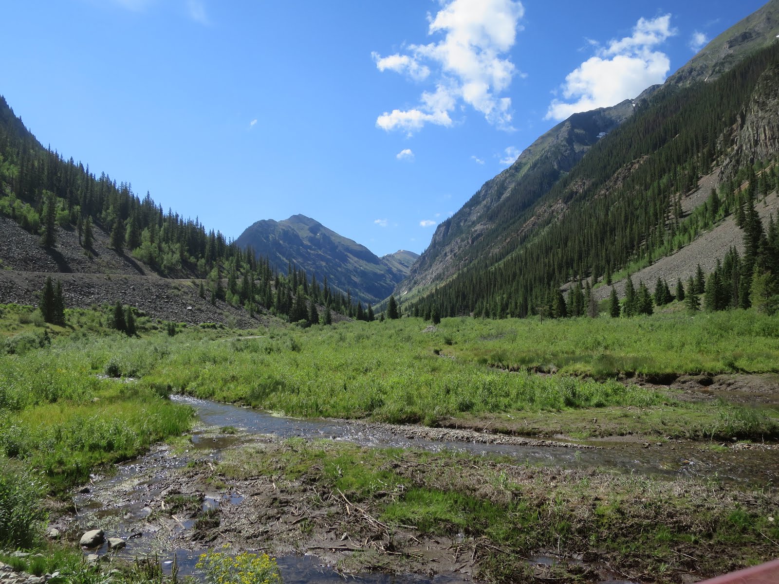
at the entrance of the Uncompahgre National Forest, had lunch next to the Uncompahgre
River.

Ouray, Colorado- History
http://www.ouraycolorado.com/about-ouray/history

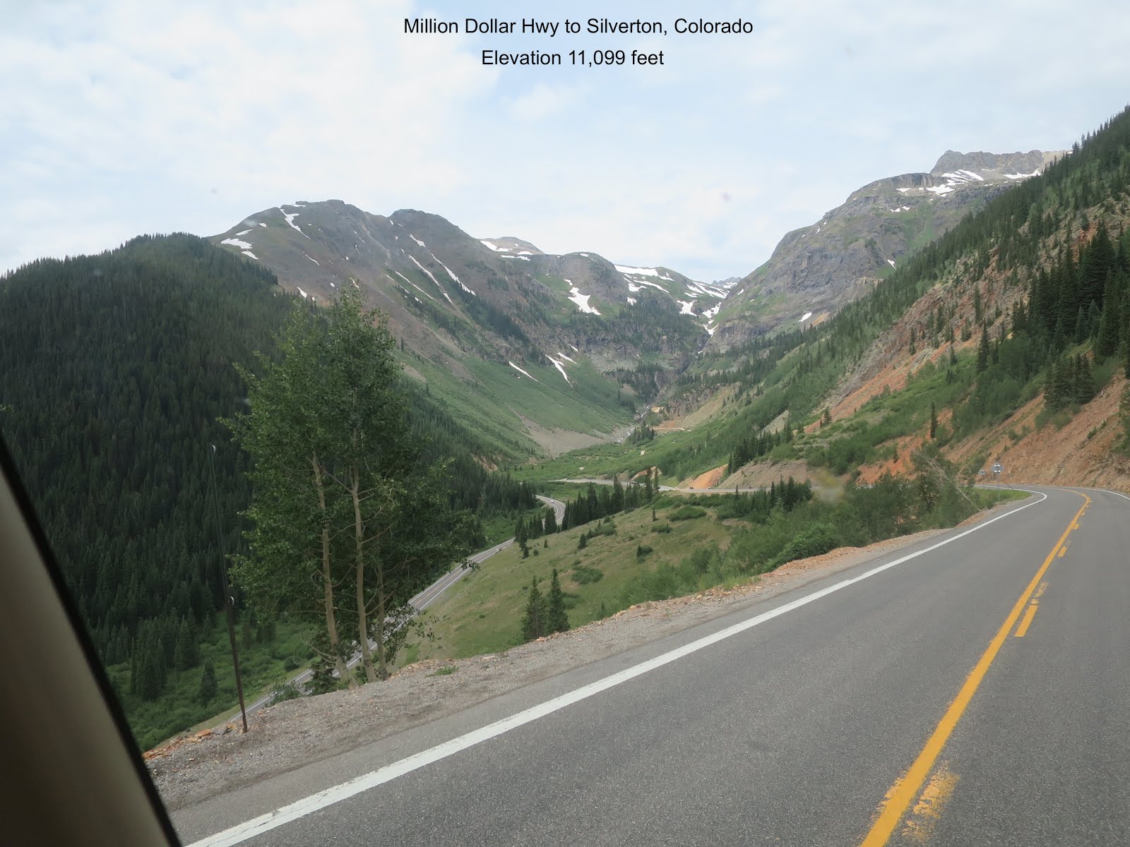
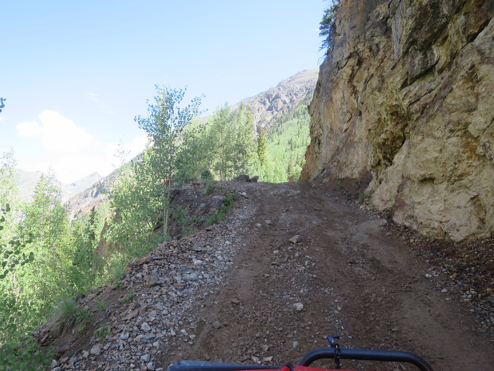
Ouray is only 23 miles from Silverton, however it took me an hour plus to navigate the switchbacks and climb the remaining 3.400 feet. I drove the " Million Dollar Hwy" over Red Mountain Pass early-morning (Less chance of overheating the motor home) since I had to climb to an elevation of 11,099-feet. Some of the switchbacks were so sharp and steep; I had the motorhome in 1st gear going 15 miles per hour.
Hwy 550 " Million Dollar Highway "


Idarado Mine & Mill
The
Idarado Mine was a gold mining operation in the San Juan Mountains of Ouray County, Colorado. The mine is within
the Sneffels-Red Mountain-Telluride mining district. The
remains of the operation are visible from the Million Dollar Highway, north of Red Mountain Pass between Ouray and Silverton. The tunnels of the
Idarado extend some 5 miles west under 13,000 foot mountains to the Pandora
Mill near Telluride, a trip of more than
60 miles by highway.
The Idarado opened up many mines in Red Mountain
District and made them successful again. In the1880’s there was a mining boom
on Red Mountain Pass. The Yankee Girl Mine was the most famous. This early
mining boom was mostly over by the mid 1890’s. Later, in 1943, the Idarado mine
leased its property to the US Government to reopen the Black Bear mine through
the Treasury Tunnel. The Idarado mined minerals for World War II. Minerals from
the mine were made into metal for making planes, ships and tanks.
In 1945 the Treasury Mill was rebuilt to mill
lead, zinc, and copper ore. In 1946, a new crusher was installed at Idarado to
increase ore production. By 1947, the Treasury Tunnel to Telluride was
complete. In 1954, a big fire burned the Idarado buildings and they were
rebuilt. By 1956, a new mill was built near Telluride. Red Mountain mill was
shutdown.


Once I reached the Red Mountain Pass summit, I kept the motorhome in 2nd gear. I didn't want to burn my brakes while maneuvering the multiply steep switchbacks, the road didn't waste any time decending the 1,800-feet into Silverton.

If you want a visual idea of the Million Dollar Highway, take a few moments and watch the below video. The video goes from Silverton to Ouray. The real challenge is going from Ouray to Silverton. I traveled the 550 both ways.
https://www.youtube.com/watch?v=55O56wsdQ4o
Silverton, Colorado


Notorious Blair Street had an extremely boisterous and very rowdy past. A number of dance halls, salons, and bordellos sprang up with the sole purpose of catering to the areas miners. http://notoriousblairstreetsilverton.com


Greene Street


Avon Hotel, rooms $ 1.50 per night (in the 1800's)


Durango & Silverton Narrow Gauge Railroad with Kendall Mountain in the background, this is the view from my motor home.

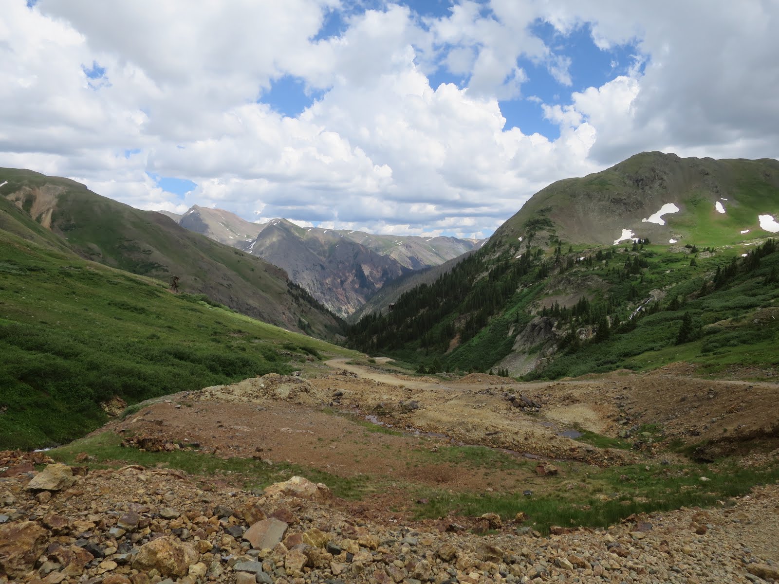
Alpine Loop

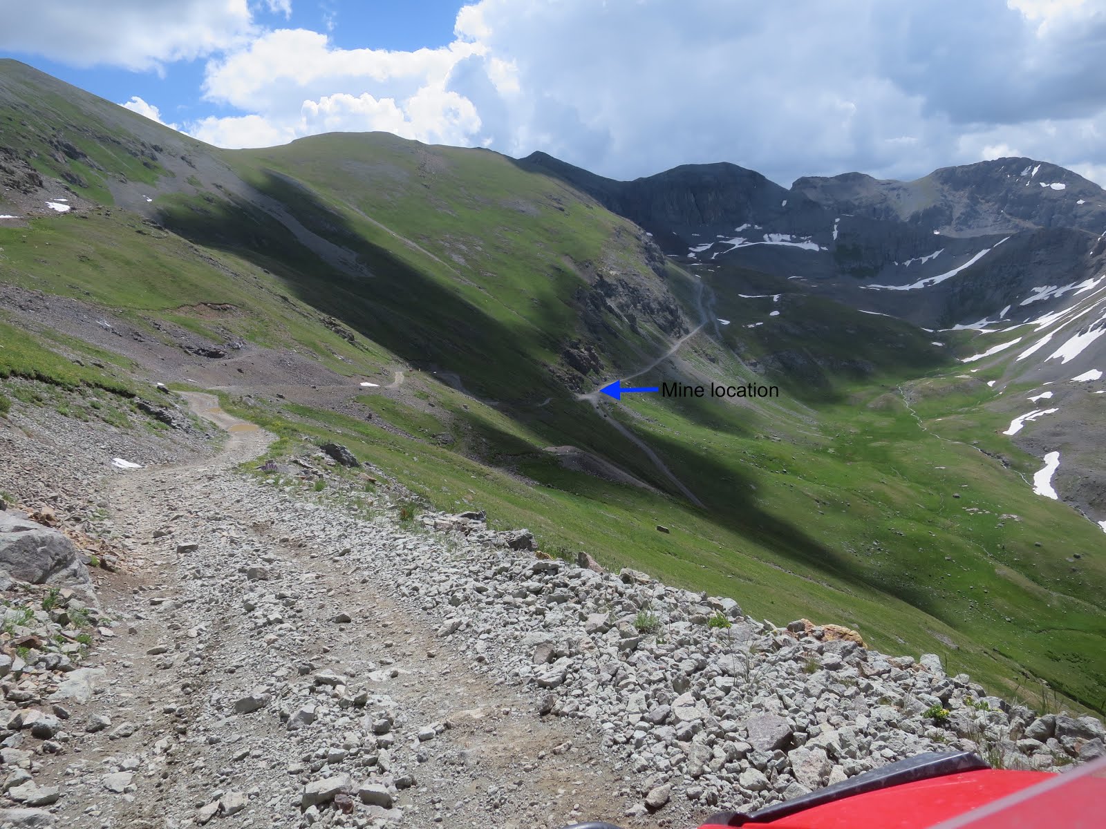
The Alpine Loop Back Country Byway was by far the longest and most challenging trail. Our highest elevation trail ride was at the 12,800-foot mark.
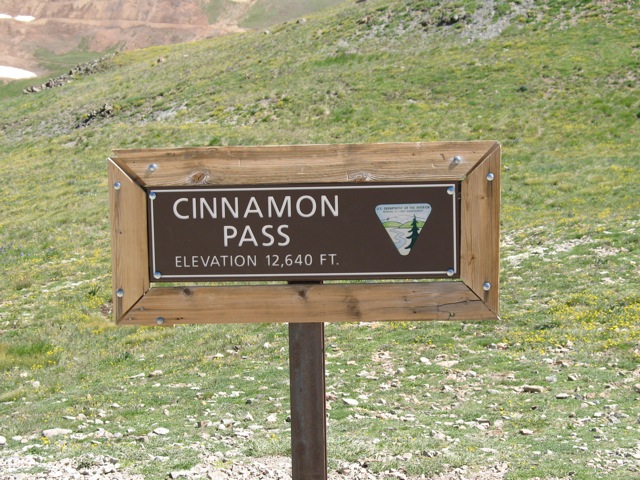
The rugged trail winds through the spectacular scenery of the San Juan Mountains. Points of interest along the way were Engineer Pass (elevation 12,800), Lake City (elevation 8,671) and Cinnamon Pass (elevation 12,620) On our way to Lake City (via engeering Pass) we took time to appreciate the amazing scenery followed by a leisure lunch at the Southern Vittles. Just as we started heading back via Cinnamon Pass, we were greeted by thunder and lighting storms so we got into our rain gear. Sight seeing was not in the cards, so I only got a few photos of Cinnamon Pass.
http://www.off-road.com/trails-events/trails/offroad-travel-colorados-scenic-alpine-loop-53523.html
http://www.off-road.com/trails-events/trails/offroad-travel-colorados-scenic-alpine-loop-53523.html?page=2
Engeering Pass


Cinnamon Pass


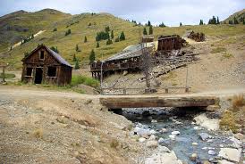
Animas Forks Ghost Town
Animas Forks Ghost Town is located on a system
of roads known as the Alpine Loop. The loop is a 65-mile system of unpaved roads, which connects the small
mountain towns of Lake City, Ouray, and
Silverton. Animas Forks, is more than two miles above sea level, (elevation
11,200).
The town's first log cabin was built in 1873
and by 1876 the community had become a bustling mining community. At that time
the town contained 30 cabins, a hotel, a general store, a saloon, and a post
office. By 1883 450 people lived in Animas Forks. Every fall the residents of
Animas Forks migrated to the warmer town of Silverton. In 1884 a
23-day blizzard inundated the town with 25 feet of snow, the residents had to
dig tunnels to get from building to building.
The Gold Prince Mill closed in 1910 and in 1917
most of the mill's major parts were removed for a new facility in Eureka. The mill's
dismantling signaled the beginning of the end for Animas Forks. The town was a
ghost town by the 1920s.
http://www.ghosttowns.com/states/co/animasforks.html
http://www.ghosttowns.com/states/co/animasforks.html


Kendall Mountain Trail - 13,451 elevation
I was able to make it to the 11,626 foot level. Snow drifts on the upper slope were to deep for me to pass. I had a great time exploring old mines and yes, the scenery was well worth the rough ride. From the top you get great views of Silverton, Route 550 (Million Dollar Hwy" ) and other local peaks.
Interesting fact about Kendall Mountain
The town of Silverton has an annual race where the participants run to the summit of Kendall Benchmark (14 mile round trip, 3748 feet elevation gain). The tradition dates back to 1908 when a miner decided to run to the summit.


Kendall Mountain complex rises directly to the southeast of Silverton in the San Juan Mountains. The area includes four peaks higher than 13,000 feet. The highest of these peaks is the 13,451 foot Kendall Peak. The Run starts in Silverton and climbs the mountain to an elevation of about 12,800 feet.


Stoney Pass - Elevation 12,650-feet


Stony
Pass used to be a major supply route into
Silverton
from the east until 1882 when the Durango to Silverton Narrow Gauge Train made it obsolete and it became just a road utilized for mining.The
old mines are still visible to this day and of particular interest is the old 100 which has many of it's buildings perched high on a mountain ledge. When entering into the mountain you can see the pick
marks made by the miners in the 1800's!
The
cable tram with ore carts attached to the massive towers on the steep hillside
are still visible at the Buffalo Boy Mine.


Maggie Gulch Trail


Minnie Gulch Trail


Eureka Sunnyside Mill Townsite

Charles Baker's group of prospectors found traces of placer gold in the San juan mountains in 1860 at Eureka. Forced by the Ute tribe out in 1861, who had been awarded the area in a US Treaty. The prospectors returned in 1871, when lobe gold was found in the Little Giant vein at Arrester Gulch near Silverton. The miners were allowed to stay after the Brunot Treaty of 12 September 1873. In exchange for giving up 4 million acres, the Southern Ute Indian Reservation received $25,000 per year. 
By 1875, Eureka had a post office. The orginal mill was closed (don't know why) but to replace it, the Gold Prince Mill from Animas Forks was deconstructed and moved to the Eureka townsite to become the Sunnyside Mill. In 1896, Eureka was connected to the Denver & Rio Grande railroad via the Silverton Northern Railroad.
Although the community grew steadily, it quickly declined after 1939, when the Sunnyside Mill closed for the last time. Today, the original townsite gravel roads remain, and debris litters the area. The only remaining building is the Eureka jail, which has been restored. Foundations remain of the Sunnyside Mill.


Low gear, four wheel drive, this baby will crawl through almost anything. Was going to take a picture half way up, water was fairly deep, didn't want to get wet.

Mayflower Mill
The Mayflower Mill is located two miles northwest of Silverton in Arrastra Gulch. The mill was built in 1929 with the latest in technology to recover gold, silver, lead, zinc, and copper from ore that was taken out of the Mayflower mine and delivered to the mill by an 9,526-foot-long aerial tramway. The complex includes the mill building, conveyor and crushing plant, tram terminal, water and coal storage tanks, and mill office building. The Mayflower was the dream od Charles A. Chase, a successful mine manager at the Liberty Bell near Telluride. The Mill was built at a cost of $375,000 using pre-framed Oregon fir. It began operations in 1930 and contuined until 1991, except for a 12-year hiatus.
The mill handled 9.7 millon ton of ore, producing 1.9 million ounces of gold: 30 million ounces of silver, and 1 million tons of other metals. The mill was officially know as the Shenandoah-Daves Mill, but Silverton residents referred to it as the Mayflower Mill because is served the Mayflower Mine. The Multi-level mill building is 252 feet long and has sections 90 feet and 106 feet wide. It has wood frame and corrugated metal on the wall and roof. The Mill offers daily self-guided tours.


Abandoned miner housing


Ridgeway, Colorado, headed up Lizard Head Pass


Lizard Head Pass
Lizard
Head Pass is a high mountain pass at an elevation of 10,222-feet, located in the San Juan Mountains of Colorado, USA. The grades on both
sides of the pass are mild. Hwy 145 (San Juan Scenic Byway) takes you over the
pass towards Durango. The San Juan Skyway is a spectacular drive through the
San Juan, Uncompahgre, Wilson and Sneffels Ranges. Colorado's first National
Forest Scenic Byway loops through the San Juan Mountains, and has been called
"The Most Beautiful Drive in America."
The pass is named for the prominent peak (13,113-foot elevation) that is said to look like the head of a lizard. It is also on the divide between the watershed of the Delores River and San Miguel River.


Arrived Priest Gulch RV Resort located along the Delores River between the cities of Rico and Delores on Hwy 145. Time to park my Polaris RZR quad and relax for a few days.


Pretty scenery but looks pretty lonely out there.
ReplyDelete